Northern France is set for a turbulent start to 2025. As a number of specialists have pointed out, a deterioration in the weather is on the way, with a risk of gale force winds, " quite classic for the season near the English Channel ", says La Chaîne Météo. The specialized site explains that " this deterioration will be driven by a low-pressure system that will deepen off the British Isles in the Irish Sea on Wednesday morning ".
At the time of writing, Météo France has placed 13 of France's départements under yellow vigilance forhigh winds on January 1, 2025. These include Finistère, Manche, Calvados, Nord, Somme, Oise, Eure, Orne and Morbihan.
On the Channel coast and in the Hauts-de-France region, gusts of over 100 km/h are forecast for Wednesday. Elsewhere, this violent gale could reach 80 to 90 km/h " from Brittany to the Ardennes, passing through the north of the Paris basin, Champagne and the north of Lorraine and the Vosges between Wednesday afternoon and Thursday morning " warns La Chaîne Météo.
So what exactly can we expect in Paris and the Île-de-France region? The wind could pick up between December 31, 2024 and January 1, 2025. That night, gusts of up to 55 km/h are expected in Yvelines. In the east and south of the Paris region, the weather is likely to be calmer.
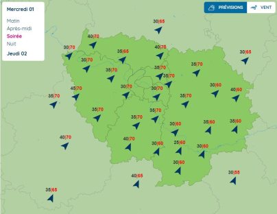
But the wind could strengthen on January 1, 2025. This New Year's Day, Météo France is forecasting afternoon winds of up to 70 km/h, again in the Yvelines.
In the evening, this gale could become widespread and sweep across a large part of the Île-de-France region, with peaks of up to 70 km/h forecast, particularly in Yvelines, Essonne, Val-d'Oise and northern Seine-et-Marne, but also in Seine-Saint-Denis and Val-de-Marne. The intensity of these gusts could continue into Wednesday night. The wind should finally lose its strength on the morning of January 2. Once again, these are only forecasts, and the coming hours will be closely scrutinized by Météo France.
Official website
meteofrance.com


