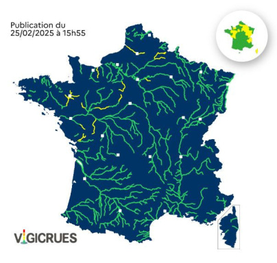
This January 25, rain is falling heavily in several French departments, including six in the Île-de-France region, which have been placed on yellow alert by Météo Francefor "rain and flooding". The passage of this new disturbance is not without consequences for France's rivers. Vigicrues has placed around ten French departments under yellow flood alert this Tuesday and Wednesday. These include Ille-et-Vilaine, Mayenne, Sarthe, Vendée, Deux-Sèvres, Calvados, Somme and Eure-et-Loir.
What's the situation in Paris and the Ile-de-France region? For the moment, only one département has been placed under yellow flood alert. This is Seine-et-Marne. This département has already been severely affected by a flooding episode last October. Remember, due to storm Kirk, the Grand Morin experienced historic flooding, with record levels and three days of red alert. For the time being, however, the situation is nowhere near as worrying as it was last autumn, as Vigicrues has placed the Seine-et-Marne under yellow vigilance.
As Vigicrues reminds us, a yellow alert is a " risk of flooding leading to localized overflows and damage, or a rapid and dangerous rise in water levels, requiring particular vigilance, especially in the case of exposed and/or seasonal activities ".
In the east of the Île-de-France region, the level of the Grand Morin river (downstream) is being closely monitored. " An undulating disturbance is currently crossing the Morins basin on Tuesday, bringing moderate accumulations," says Vigicrues, adding that " a rise in levels is expected from this afternoon, with the maximum expected in the Pommeuse sector tomorrow (Wednesday, ed. note) during the morning ". It should therefore be a"low flood", all the more so as the rain should soon stop and give way to bright sunshine from Thursday February 27 onwards.
Official website
vigilance.meteofrance.fr


